Papua New Guinea assesses extent of damage from strong quake
Published:Wednesday | May 15, 2019 | 10:00 AM
WELLINGTON, New Zealand (AP) — Papua New Guinea authorities were assessing the extent of damage Wednesday from a powerful earthquake that rattled coastal towns the previous evening.
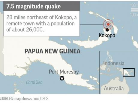
The magnitude 7.5 quake struck around 11:00 p.m. Tuesday at a relatively shallow depth of 10 kilometers (6 miles), according to the U.S. Geological Survey. It was offshore about 45 kilometers (28 miles) northeast of Kokopo, which has about 26,000 people.
Chris McKee, the acting director of geohazards management, said there was some damage in Kokopo as items were shaken from shelves and the power had been cut.
He said a small tsunami was generated, but the late-night darkness made an assessment difficult.
McKee said the earthquake was a strike-slip event along a fault line, a type of quake that doesn’t usually trigger major tsunamis.
Garfield Tarabu, a spokesman at the National Disaster Centre, said a disaster coordinator was on the ground assessing the situation in and around Kokopo but they hadn’t yet gotten an update on the extent of the damage.
The U.S. Pacific Tsunami Warning Center had said tsunami waves of up to one metre (3.3 feet) were possible along coastal areas up to 1,000 kilometers (620 miles) from the epicenter, including Papua New Guinea and the nearby Solomon Islands.
Papua New Guinea is located on the eastern half of the island of New Guinea, to the east of Indonesia and north of eastern Australia.
We want to hear from you! Send us a message on WhatsApp at 1-876-499-0169, email us at editors@gleanerjm.com or onlinefeedback@gleanerjm.com.