Isaias near hurricane strength as it crawls toward Carolinas
Published:Monday | August 3, 2020 | 12:36 PM
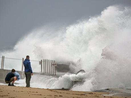
MYRTLE BEACH, South Carolina (AP) — Isaias was forecast to strike land as a minimal hurricane on Monday in the Carolinas, where coastal residents were warned to brace for flooding rains and storm surge.
The US National Hurricane Center issued a hurricane warning from South Santee River, South Carolina, to Surf City, North Carolina.
Isaias was still a tropical storm at 11:00 a.m., with maximum sustained winds of 70 miles per hour, but it was expected to strengthen into a Category 1 hurricane later Monday, with winds of 74 miles per hour or more.
“We are forecasting it to become a hurricane before it reaches the coast this evening,” senior hurricane specialist Daniel Brown said.
“It’s forecast to produce a dangerous storm surge, of 3 to 5 feet in portions of North and South Carolina.”
Isaias — pronounced ees-ah-EE-ahs — could bring heavy rains, too — up to 8 inches in spots as it moves up the coast, Brown said — and “all those rains could produce flash flooding across portions of eastern Carolinas and mid-Atlantic, and even in the northeast US.”
Isaias killed two people in the Caribbean and roughed up the Bahamas but remained at sea as it brushed past Florida over the weekend, providing some welcome relief to emergency managers who had to accommodate mask-wearing evacuees in storm shelters.
It remained well offshore as it passed Georgia’s coast on Monday.
Follow The Gleaner on Twitter and Instagram @JamaicaGleaner and on Facebook @GleanerJamaica. Send us a message on WhatsApp at 1-876-499-0169 or email us @onlinefeedback@gleanerjm.com or editors@gleanerjm.com.