Patricia Green | Stop blaming climate change for flooding
“… If it rains heavily enough and long enough, there will be flooding … ” wrote L.C. Nkemdirim and Eleanor B. Jones in ‘Flood Regions in Jamaica’, having studied, mapped, and published in 1978 the flood pattern on the island. The peak period, accounting for two-thirds of all flooding, occurs in October, extending into November and December. There is a secondary peak in May (about 12 per cent) while the rest of the year is, for all practical purposes, flood free.
Using streams and gauging stations to obtain a ratio from a 10-year flood to the mean annual flood, Jamaica is divided into four distinct regional characterisations: (1) “Blue Mountain Region” (roughly Portland, St Mary) is the highest average - 2.75 units - containing high rainfall and steep slopes; (2) “Central and West Coast Region” (roughly Mandeville, Clarendon, St Catherine, St Ann, Hanover, Westmoreland) with modest highlands and modest rainfall average 2.17 units; (3) “Southeast Coast Region” (roughly St Thomas, Kingston, and St Andrew) averages 1.80 units with generally low rainfall because it lies in the rain shadow of the east-west running mountains; (4) “Cockpit Region” (roughly Trelawny, St Elizabeth) with large numbers of sink-holes, resulting in the flow being primarily subterranean, therefore, floods are rare, having average 1.40 units that is almost imperceptible.
With this scientific understanding, what has transpired over the years to convert even the slightest inundation outside of October and May into national flood disasters of catastrophic proportions resulting in loss of housing, businesses, livelihoods, and, sadly, even lives? What guides policy and planning framework for flooding disaster-risk reduction with management strategies, also mitigation with resilience and adaptation? What is impeding the natural runoff and flow of water moving from the Jamaica central hill spine and travelling to the sea? Government is aware of the intense weather implications from global warming and climate change. It is now action time.
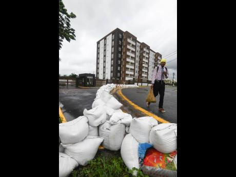
The Observer, September 28, headlined ‘Another warning: PM again cautions against building in flood-prone areas’ reporting the Prime Minister, ‘…”we are building in areas that are flood prone; we’re getting rain in short bursts in unpredictable seasons that is going to put your housing and your lives at risk and it cannot be that at every event there is a cry to the State to restore housing or rebuild roads. These things are not feasible …”. Additionally, Minister of Local Government and Rural Development Desmond McKenzie said: “… Jamaicans living in those areas had ignored warnings to evacuate in the past, more than 600,000 people were living in 754 informal settlements across the country … 585 of those communities had been mapped, and 138 of them were located within 100 metres of waterways ...”
PERCEPTION
There is a perception that the issues of flooding are primarily affecting informal housing and that citizens living in these communities should “evacuate” from such vulnerable locations. Many communities being called ‘informal’ have historically been settlement areas generationally since the 1834 emancipation from enslavement. The National Land Agency (NLA) should consult the cadastral maps for settlement patterns on formerly enslavement plantations, noting that many are along rivers for access to water. Most rivers are currently channelled inside gullies. If any “evacuation” is required, then it should be the remit of successive governments to make available suitable Crown lands for relocation of any vulnerable community. Today, the cry remains for affordable housing, and the Ministry of Housing and National Housing Trust (NHT) should define affordable to which income group.
The responsibility ultimately resides with the State because Housing, NLA, NHT sit with the Ministry of Economic Growth and Job Creation with other portfolios such as National Works Agency (NWA) /Natural Resource and Conservation Authority (NRCA) /National Environment Planning Agency (NEPA). Kudos to local and central government efforts to clean drains and clear gullies. However, what happens when these entities ignore historic and scientific patterns of the physical geography of Jamaica? Do they issue approvals for new developments inside vulnerable settings even after citizens object? In Manchester, a bank was constructed despite local protests inside a sinkhole and is repeatedly closed because of flooding. Are there other examples?
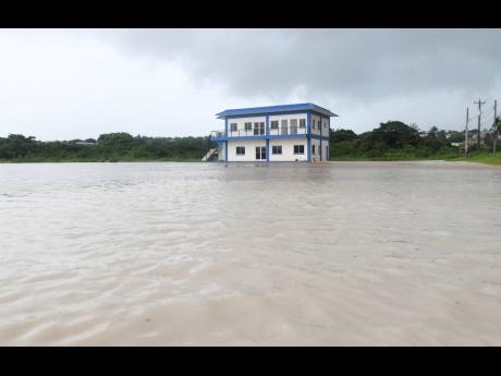
The NWA expansion of roadways and highways blocking the passage of water through towns is filling traditional and social media with cries from various citizens to stop flooding their communities. Gas stations, banks, and other commercial enterprises are now being flooded, including school buildings that should have been used as disaster places of refuge. Additionally, residents of the 1,800-units Harbour View Heights (ca. 1960), have been asking the NWA since 2018 to repair a faulty drainage system it erected on their boundary, eroding their land and undermining their houses. How many other communities are experiencing such impacts?
COMMUNITIES PROTESTING
The NRCA has ultimate responsibility for the beaches for Jamaicans, yet communities are protesting that their requisite access to beaches is being denied. The media have carried these cries from the parish of St Ann’s, Bluefields in Westmoreland, and Montego Freeport in St James. Recognise that even as citizens are denied access so, too, is the passage of water where fencing erected across the landscape blocks freedom of water movement into the sea, resulting in severe flooding with intensity in new communities and destroying adjacent roadways. Are there other communities experiencing similar denial of access to beaches with boundary walls causing flooding?
The NEPA is responsible for town planning and subdivision approvals, including its Jamaica National Spatial Plan (1970–1998). This must be updated, especially considering the climate change dialogue. Issuing subdivision development approvals inside floodplain areas becomes critical because the onus is placed on the developer to install systems for sewerage, drainage, and flood controls, yet often, these contain inadequate projections and/or suffer lack of maintenance afterwards.
In Trelawny, “Residents will be exposed to flooding: Environmentalist worried over Falmouth’s multimillion-dollar expansion” headlined The Gleaner September 1, 2021, “… while the project is ongoing, it would appear that the NEPA is not on board with what is unfolding …” These are mangrove lands at the lower section of Market Street, and the Disaster Management Committee said that should there be a hurricane, the town could be severely flooded. In Clarendon, citizens issue concerns that NEPA permitted agricultural lands to be converted for housing instead of being preserved to address food security and that its Nightingale Grove housing development is plagued with flooding, also predicting a similar fate for Spring Gardens development, where there is a river, reported The Observer June 28, 2010, “Leave agricultural lands alone”. Are there other similar communities?
May we stop blaming ‘climate change’ and/or the citizens of Jamaica for any seemingly state agency planning and development negligence that may be resulting in increased intense flooding across Jamaican communities.
Patricia Green, PhD, a registered architect and conservationist, is an independent scholar and advocate for the built and natural environment. Send feedback to patgreen2008@gmail.com.


