Update | Jamaica still under hurricane warning
Published:Tuesday | July 2, 2024 | 6:33 AM
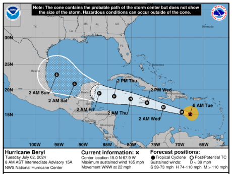
A hurricane warning remains in effect for Jamaica as strong category 5 Hurricane Beryl continues to move quickly to the central Caribbean.
This means that dangerously high water or a combination of dangerously high water and exceptionally high waves are expected to affect Jamaica in 36 hours or less.
Beryl has average winds of at least 119 km/h (74 mph).
At 4:00 a.m. the eye of Hurricane Beryl was located about 1,120 kilometres (695 miles) east-southeast of Kingston.
The Meteorological Service of Jamaica says while the hurricane is expected to begin weakening later today, Beryl is still expected to be near hurricane intensity as it moves into the Central Caribbean and passes near Jamaica on Wednesday.
It says, based on the current forecast track, the eye of Hurricane Beryl is expected to move just southeast of Jamaica on Wednesday morning and then follow a path adjacent to the coastline throughout the day.
As the centre of Beryl moves closer to Jamaica, residents are being told to expect heavy rainfall to begin affecting the island early Wednesday morning.
This will later be accompanied by possible hurricane force winds across the island and dangerous storm surges and battering waves along mainly coastal areas of southern parishes.
Follow The Gleaner on X and Instagram @JamaicaGleaner and on Facebook @GleanerJamaica. Send us a message on WhatsApp at 1-876-499-0169 or email us at onlinefeedback@gleanerjm.com or editors@gleanerjm.com.