Permit denied
Regulators note Alligator Pond’s extreme vulnerability in saying no to proposed mining
A mining company that proposed a multimillion-dollar business for Alligator Pond in southern Manchester will have to look elsewhere after Jamaica’s environment regulators refused its application for a permit, citing the potential for worsening coastal erosion.
Earlier this year, Ready Sand and Gravel Limited applied for an environmental permit for the mining and quarrying of bauxite, peat, sand, and minerals – including aggregate, construction and industrial materials, and metallic and non-metallic ores.
However, at meetings on December 19, the Natural Resources Conservation Authority (NRCA) and the Town and Country Planning Authority (TCPA) refused the application, for two reasons.
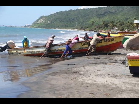
In the first, the authorities explained that the proposed mining could be detrimental to Alligator Pond, a popular food spot and fishing village that stretches roughly two miles along the coast. It is about 22 miles from parish capital Mandeville and sits at the Manchester-St Elizabeth border.
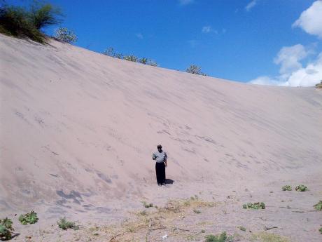
The regulators pointed to the situation with sand dunes or mounds of sand, which contribute to the coast’s natural ability to buffer against sea surges and erosion during storms.
They said the coastline in the area exists in a state of “dynamic equilibrium”, which essentially means that the coastline has as much sand leaving as arriving, suggesting that any mining-related activity could be too disruptive.
Environmental degradation
“Anthropogenic pressures, inclusive of the proposed activity (if approved), can potentially lead to environmental degradation as well as negative impacts on the coastal communities,” said the NRCA and TCPA, referring to human actions that drive environmental change such as global warming.
For the second reason, the regulators said the wider Alligator Pond area has been identified as “extremely vulnerable”, especially with the declining shoreline, and is included in an ongoing assessment for corrective actions to be taken as part of a Government of Jamaica and World Bank study.
“Therefore, the proposed activity, if approved, will be counterintuitive to any proposed restoration/mitigation activities to be in the area,” the agencies said in their decision that has been posted to the website of their administrator, the National Environment and Planning Agency (NEPA).
Experts and local interests have expressed fears about the coastline’s erosion through sea level rises among other factors and the threat to fishing and related businesses in the area of over 2,000 residents spread across five communities.
The decision has been hailed as a “good call” by Diana McCaulay, one of the country’s leading environmentalists, who noted that Alligator Pond requires urgent attention to protect its coastline.
“Those large sand dunes are an extremely important buffer against storms or sea level rise. We should be protecting all sand dunes wherever they exist. We’ve lost a lot of them already, of course,” said the former chief executive officer of the Jamaica Environment Trust.
“The natural systems like the sand dunes and stuff protect whatever is on the land – people, buildings … . You don’t want to take them out. You don’t want to go and mine them.”
It is not clear whether the mining company will appeal the decision, which is a right it has under the NRCA Act.
Businessman Jamey Taylor, who, according to Companies Office of Jamaica records is one of two listed shareholders in the company, told The Sunday Gleaner last Friday he would provide a statement on the matter, but none was received up to press time.
Under the law, the minister responsible for the agency – in this case, Minister of Economic Growth and Job Creation Andrew Holness – may overturn the regulator’s decision after considering an appeal.
Alligator Pond is one of eight locations in the Jamaica Disaster Vulnerability Reduction Project being financed through a loan from the World Bank and implemented by the Jamaica Social Investment Fund.
Coastal assessments
Under the project, an environmental study was planned for the Alligator Pond and the other areas, Port Maria, Manchioneal, Ocho Rios, Morant Bay, Black River, Savanna-la-Mar, and Portland Cottage.
Along with the coastal assessments, solutions were expected to be designed to address the problems found in the various locations.
NEPA is a partner on the project and Anthony McKenzie, who is the director responsible for the environmental management and conservation, said the assessments were completed about April this year. A request for proposals was issued in 2018.
“One of the key features of the assessments was to also support what we call nature-based solutions. So, it’s not only in terms of hard engineering works, but is how the natural resources can be further enhanced,” he said, pointing to the recreation of sand dunes and the installation of artificial reefs.
McKenzie said there are discussions with the World Bank to secure funding for the implementation of the solutions.
“Mi did deh far from the sea and it just come in whole heap. The seafront just mash up,” lamented Clinton Ford, an Alligator Pond resident, in an interview with The Gleaner in 2021.
He said then that the distance of the shoreline from his property was frighteningly close compared to when he was younger.


