Hurricane warning now in effect for Jamaica as major Hurricane Beryl continues on a track towards the island
Published:Monday | July 1, 2024 | 9:31 PM
The Hurricane Watch for Jamaica has been upgraded to a Hurricane Warning as Category 4 Hurricane Beryl continues to move over the eastern Caribbean on a track towards the island.
This means that the following dangerous effects of a hurricane are expected to affect Jamaica in 36 hours or less:
Dangerously high water or a combination of dangerously high water and exceptionally high waves, even though winds expected may be less than hurricane force, and
Average winds of at least 119 km/h (74 mph).
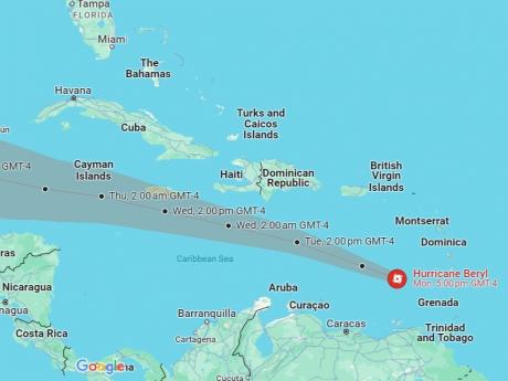
At 7:00 p.m. the eye of Hurricane Beryl was located near latitude 13.4 degrees North, longitude 64.0 degrees West. This is about 925 kilometres (575 miles) east-southeast of Isla Beata, Dominican Republic, or 1,460 kilometres (910 miles) east-southeast of Kingston, Jamaica.
Beryl is moving toward the west-northwest near 33 km/h (21 mph). The centre of Beryl will move farther away from the southern Windward Islands tonight and continue westward to west-northwestward during the next few days.
On the forecast track, the centre of Beryl will move across the southeastern and central Caribbean Sea tonight through Tuesday and is forecast to pass near Jamaica on Wednesday.
Hurricane Hunter aircraft indicates that maximum sustained winds have increased to near 250 km/h (155 mph) with higher gusts.
Beryl is a strong Category 4 hurricane on the Saffir-Simpson Hurricane Wind Scale. Fluctuations in strength are likely during the next day or so, but Beryl is expected to remain an extremely dangerous major hurricane as it moves over the eastern Caribbean. Some weakening is expected in the central Caribbean by midweek, although Beryl is forecast to remain a hurricane.
Hurricane-force winds extend outward up to 65 km (40 miles) from the centre and tropical-storm-force winds extend outward up to 205 km (125 miles).
All small craft operators, including fishers from the cays and banks, should by now be in port and are urged to complete their necessary safety precautions without delay.
The Meteorological Service of Jamaica continues to monitor the progress of Hurricane Beryl and all interests are encouraged to pay special attention to further Releases.
The Met Service will issue the next Bulletin on this system at 11:00 p.m. today.
Follow The Gleaner on X and Instagram @JamaicaGleaner and on Facebook @GleanerJamaica. Send us a message on WhatsApp at 1-876-499-0169 or email us at onlinefeedback@gleanerjm.com or editors@gleanerjm.com.